I do not consider myself a competitive person. However, when an idea is offered that is fresh and maybe borderline insane … I am usually up for the challenge. While trekking in Nepal on a humanitarian medical mission, I crossed paths with Lance, an adventure spirited vagabond MD who enjoys riding bicycles. During a morning run, barely knowing each other, we decided it would be a good idea to bike tour on a tandem for 10 days in the Pacific Northwest. Neither of us had ridden a tando before but figured that, with our combined will and experience riding solo on two wheels, what could go wrong?
Fast forward a year later and here we are in St. George, UT, to begin our second tandem excursion. This time on his very own Co-Motion Co-Pilot tandem. This vehicle is a 1999 steel framed road touring bike with torque coupling so it packs neatly for travel, with 700c/35mm road slick tires, and with front and rear racks. It’s a smooth riding beast, having all the finesse of a road bike, able to drop the hammer when need be, and yet stable enough for the dirt and gravel terrain.
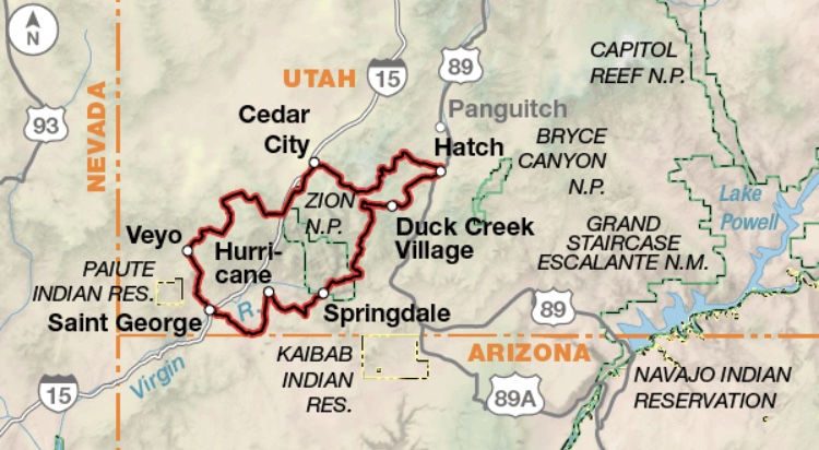 The Plan – 5 days to conquer the Adventure Cycling Association Utah Cliffs Loop. A 287.6-mile loop in the “Color Country”. This southwest region of Utah, blessed with an array of vibrant hues, from the red rock cliffs and buttes to the lush forest that this route journeys through.
Day ONE

We arrived 6 miles northwest of St George in Santa Clara to begin our tour. It’s past noon and a glance at the temperature gauge inside the Sprinter said 114 degrees. As a NW dweller for over a decade, this heat is not something one acclimates to quickly. It’s maybe worse than subjecting oneself to a spin bike in a Bikram room since our goal is to ride northward 40 miles to Pine Valley campground in a rustic town tucked within the mountains.

The letters HEAT STROKE in bright red lights blink in my view mentally. Being the stoker, my job is to provide the engine to the drive train. So what to do but take the two electrolyte pills, fill bottles pre-loaded with Skratch, pop a few ibuprofen, and grab three more bottles of H20 as we set off? The paved asphalt trail we hopped onto may have lasted 5 miles before transitioning to a dirt path for much of the way following the ACA bike route. The single track gravel climb revealed a commanding vista of the surrounding cliffs as we meander through Snow Canyon State park. One mistaken turn meant we had to turn back to find the correct way, then the Snow Canyon Drive “lung burner” hill climb in this heat made it unbearable as the hot dry air continued to beat down on us for hours. The challenge of staying cool seemed impossible as the cold water in our bottles quickly heated up, and the tea-temperature water didn’t provide much relief.
We found a pit stop at a campsite a few miles before the junction with route 18. Shaded bench and a spigot in view, I beelined over to fill up our water bottles and drenched my neck to cool down. Wise man Denny, an ex-domestique of Le Tour, taught me many lessons of the bicycle, but it’s the “ice sock” lesson – Pearl number one – that I am most grateful for at this moment. (Fill a knee-high sock with ice and wrap it around your neck). Both of us, not being in our best cycling shape prior to this ride, felt the physical stress of exerting ourselves in the scouring dry temps. Route 18 guided us towards Veyo where we would revive a bit before the final 10 mile climb up to Pine Valley where we planned to camp for the night.

My brain scrambled from the heat, I’ve about had it with the conversation between my muscles and tendons. The resemblance of a few ramshackle buildings framing the road appear as a mirage from a distance as I stare across the valley floor. It is around 5pm. We slow rolled into this small town while surveying our options in Veyo; at the sight of the pie shop my stomach lets out a hangry plea to stop. We anchored down at the five-n-dime store instead. Barely able to move, at turtle speed I get one leg over off the rear seat and stand on solid ground. The pain of a calf cramp sets in as I hobbled toward the sliding door where cool air awaits on the other side. A Coke and chocolate milk to quench our thirst, we take the cashier’s advice and head over to Slice of Veyo a few doors down.

For as long as I’ve known Lance, the indomitable spirit and rugged exterior he exudes tricks one into thinking he is bulletproof. However, even this Hugh Jackman has to yield sometimes. Head drooped over his arms on the table exhaling in abbreviated gasps, he mumbles: “I have a headache, thumb cramp, and my stomach is not good. This is bad.” He continues, “It’s happened before, like almost every bike tour I’ve done. The first day is miserable, then I’m fine after that the rest of the way. Maybe I can rest a bit and climb those last 10 miles later.” He is worn out, defeated, and I am wondering whether this trip is going to end before we even really begin.
As curious creatures and social beings, people have an affinity to approach wandering folks to spark up a few words with them. Be that person a thru hiker or a person on a bike tour, it seems that something draws them to the mystery of where you’ve been, or where you might be heading. Your story provides a glimpse of a life or experience they wish for, or nostalgia for ones they might have had. Or maybe they’re just trying to vicariously live through you for a moment. The people we met in Veyo were very generous and that generosity was gratefully received as we both pathetically rested for a few hours in a booth of the pizzeria. Owner Dan, and a patron named Doug who was dining with his wife that evening, offered us a ride up to Baker Dam reservoir, about 5 miles uphill from Veyo. As Dan would not be closing up for another half hour or so, we succumbed to the reality that we were incapable of biking the last few miles to the reservoir. We took Doug up on his offer and loaded the tandem into his truck bed.
The tranquil sound of mother nature in our ears, and with serene water in view, we pitched our tent and settled in for a nightcap. It’s 9pm and we’re hopeful that a good sleep will give us the energy for what’s ahead.
DAY TWO

The 5:30am alarm beckons us to rise. I offered my “5 more mins” for snoozing, and no objection from The Captain this time. We efficiently pack, prep old blue steelie, and off we go to chase the sunrise. Our goal is to make up those 10 miles, have brekkie in Pine Valley, then complete the rest of the route we planned for today. We hope to reach Cedar City by midday or early evening. Just as he predicted, with his neutral complexion and feeling like a new man (almost), Lance is ready for launch. We spent an hour or two riding uphill from the reservoir, and then down to the pastoral settings of Pine Valley, an angelic little town. We encountered a few locals to ask about a store or gas station for food. This being my first visit to this region, the vast plains of rural America provided outstanding landscapes to drool over, but lacked many of the amenities one is accustomed to in urban areas. The only store in town opens at 11am and there is nothing in the near vicinity for at least another 15 miles. Fortunately, the church up the street has a water spout and a concrete area with steps where we can sit and rest. We perched ourselves on the steps of this adorable chapel surrounded by a well-groomed lawn surrounded by a white picket fence to cook a camper style meal for two. From that point on, we kept our extra water bottles in our panniers since they seemed to stay cooler there rather than in the open air.
Fuel and a short nap was a kick start to power on. We opted to follow the suggested route initially and remained on gravel roads, but then took a slight detour from the ACA map route in order to merge onto highway 56. The monotony of riding the undulations of the sandstone canyons seemed peaceful to me as I became entranced in my pedal strokes. A flowing meditation. Honestly, most of the events of day two are a blank for me as I was focused internally. It’s a state of mind I tap into on long runs as well as to quiet my mind to make space and get centered. We powered our way through the last miles of the day without mishap, arriving in Cedar City by 2pm. We treated ourselves to a well deserved stay at a Ramada inn and ate top notch barbecue: ribs, pulled pork, and Frychos with the works at Sonny’s BBQ. “The best” BBQ
Planning ahead over dinner, we knew we had a huge day in store for us, likely to end up over 10,000′ in elevation before arriving at our campsite at Panguitch Lake.

DAY THREE

Our morning began with our very own king/queen of the mountain stage as we tackled almost 4500′ of climbing at an avg 8% grade up the Cedar Canyon slope, high onto the Markagunt Plateau of the Dixie National Forest. The breathtaking 15 miles of Cedar Canyon engulfs highway 14, and made the arduous climb tolerable. Brief rays of light play peekaboo through the mountains. Every once in awhile, I looked up to take in the view, forgetting the destination for a few moments.


Being on a tando differs greatly to solo climbs in that two very strong riders may not necessarily yield a high performance. It most definitely puts the cooperative effort to the test. After 24 miles, with mini stops for fuel and rest and photos, we reached Cedar Breaks National Monument for a break of our own. We’ve been riding 4.5hrs. Both feeling “high-fiving” accomplished and exuberant that the climb for today is over, we survey the Chessman Ridge lookout and Rim Visitor Center. Much to our dismay, the murmurs and sandwich board signs around the visitor center confirmed the closure of highway 143 due to wildfires burning near Brian Head, northeast of us; evacuations were ordered near Panguitch Lake, our planned destination for the day. My heart sank for a moment or two, refusing to believe the rumors, and I wanted to push forward anyway. We have a destination, damn it!, and I am not about to cut 50 miles from our adventure to detour to Navajo Lake until I know for sure. Disappointed in the news as well, Lance (being the rational one), was adamant we head southeast towards Duck Creek Village and Navajo Lake. I can admit to occasionally sulking quietly when I am overruled – for the right reasons in this case. After a silent meal, we got back on the saddle for a gentle descent to Navajo Lake Campground.


We didn’t have a reservation for Navajo Lake that day, but Lance was confident we would find a spot. After considering several different campgrounds and campsites, we settled on a somewhat shaded area overlooking the water and took a dip in this very large mountain lake to cool off. Our food stash was meager since we had plans to stop and stock up at a store at Panguitch Lake to replenish our supply, but there were no stores at all along the route to, nor anywhere near, Navajo Lake. After a wee bit of persuasion from The Captain, I went over to meet our friendly neighbors, to either ask for a ride into the village 5 miles away, or to freeload for some eats. They invited us over later in the evening for dinner, and we gladly accepted (the Ramen noodles and instant potatoes we had just weren’t enough to fill our bellies). On our hardest of days so far, the universe, and believing in the kindness of others, provided some good karma and some good eats. These people will never know how much this meant to us since we would not reach another place to eat (we looked forward to stopping at the first little “greasy spoon” we encountered) the next morning til 35 miles out the next day. It’s past 10pm, we retreat to our Cotopaxi to find some warmth, and stray gusts of wind forced us to acknowledge how unprepared we were for the drop in temperature at this elevation (9000’). We make do with our provisions, and with my one eye open to witness the stars, we find comfort among each other to look forward to another day.


DAY 4

The dewy morning air seeped through the covers, sending chills through my entire body. Barely having gotten a wink of sleep, I ignore the alarm the first time it goes off. Based on our maps, today’s route should be our easiest so far since it’s overall a net descent, taking us through North Fork Canyon, the eponymous river below being a branch of the Virgin River, the river that carved and shaped Zion National Park (ZNP). From Navajo Lake, the 13 mile gravel North Fork road will gradually descend some 4000’ to merge at SR 9 east of ZNP. Knowing the terrain we’ve encountered thus far, this should be a cruise even if the surface is somewhat uneven. We were again struck by the unexpected.
As we traverse to the turnoff from Navajo Lake Rd, veering left revealed a path of hardened rocky surfaces with loose gravel and large divots stretching as far as my eyes can see. If I wasn’t afraid before, I sure had some trepidation with moving forward. But there was no point in dwelling on the negative, but rather to focus on the task at hand to survive without dying or having mechanical failures. Fortunately, The Captain has some mountain bike experience, and based on the fact that we survived our previous tandem adventure without crashes or major injury, I felt confident we would get through this unscathed. Maybe. The continuous braking, nearly to the point of seeing smoke on our rims, and tension of riding downhill on rough, rocky, uneven roads, was it’s own kind of exhausting, so much so that some of the interspersed steep climbs were almost a relief. Thankfully, we eventually came upon smooth pavement once again and cruised down towards ZNP, often at 30+ mph. We made it down to High Road campground, just outside the entrance of ZNP, and stopped for pizza across the road. It’s our first meal of the day, 35 miles so far. Pearl number two – my saving grace to avoid serious painful saddle sores is to apply ample amounts of Aquaphor, pre and post riding daily. Despite some minor visible bruising, the soreness, though ever present, was bearable.


After a few touristy photos at the entrance sign, and The Captain with his Go-Pro latched on his helmet, we head for the commanding 10 mile stretch of switchbacks, slickrock, tunnels and sweeping views of the Zion-Mt Carmel highway. The highway features two tunnels blasted through deep sandstone. It was, at one time, the longest non-urban road tunnel in the United States. Hikers and cyclists are prohibited in the 1.1 mile tunnel, and there are no shuttles to ferry you through, so you must hitch a ride. I am not accustomed to soliciting people for a ride, but The Captain had no such qualms about it. Luckily, after a few failed attempts, a kind man named Brian, with his sleeping toddler in the back seat, invited us on board. We threw the bike and our bags into the truck bed, and he ferried us through the tunnel. We regrouped on the other side, then rode into the main section of the park, eventually reaching the Watchman campground of ZNP. With crossed fingers, hoping for a camp spot as this was an unplanned stop and you cannot make reservations ahead of time, we got lucky and the camp hosts showed us a site that was available for the evening. It’s 3pm or so by now. We mingled with a young couple bike touring across the USA, and chit chatted at length with Tomi, the old chain-smoking Finnish guy with a customized Mercedes-Benz Sprinter, to collect ideas for Lance’s sweet ass van. Then we took a casual bike ride just outside the park and into Springdale for a proper meal and beverages. This was about all the energy we had before the fatigue set in from the day. It’s days like today that you know you earned a good night’s sleep.

DAY 5

My dear friend told me once she doesn’t recall having dreams, and I initially wondered if that was even possible. On the other hand, my vivid visions can wake me up in a pool of sweat. This morning was one of those. It’s possible I was anticipating what would be the longest day of riding. Saving “the best” for last, almost 70 miles still remain in the saddle before reaching our final stop in Santa Clara, Utah. A “cry baby hill” at 10% grade for 1.3 miles to start the day loomed large, followed by rolling hills through the Smithsonian Butte and Gooseberry Mesa.

We say farewell to the indescribable beauty of Zion and head southwest. It’s 7am, and already you can feel the heat starting to build. We traverse through Rockville where the route become ripples of gravel and dirt. A neon yellow sign standing in the tall grass reads, “HAZARDOUS ROAD AHEAD … USE AT YOUR OWN RISK” at the beginning of what appears to be a very steep and badly washboarded road. I mean, it can’t be that bad right? As two willful souls, we do what’s needed, as the only way to greener pastures is to continue on. I am a huge fan of Cyclocross and there is no shame in pushing the bike instead of riding it when needed, which is what we do. Fortunately, this cobblestoned, pockmarked stretch of road only lasted a short distance before leveling out, subsequently followed by relatively gentle rollers as I breathe sighs of relief. A turn onto SR59 was our first stop for food.


When all else fails, a petrol station is where you might just find the “greasy spoon” meal of your dreams. The fantasy talk of donuts and biscuits with gravy and bacon-sausage earlier that morning came to fruition at this gas-mart. Lance surveys the route realizing the conundrum of two options – choosing the shorter state route with high traffic versus the likely more scenic, but unpredictable, variegated trail we’ve come to know so well. Deferring to me to make the final decision, knowing a life with regrets is not part of my MO, I suggested going the long way. Deep down I felt this was what he wanted as well. From the state route, we veered back onto gravel roads, the final descent of the morning being a very steep drop into Hurricane via a rocky trail better suited to a mountain bike. The remaining distance from Hurricane to St George was another 30 miles through back-country gravel roads.
Totally exposed, with the hot sun beating down on us and without any shade in sight, we take small sips to conserve our water. This gradually descending downhill road was breathtaking with its expansive views of Sand Mountain to the right and the Hurricane Cliffs to our left. Parts of the route felt like scenes from the movie The Martian with the red rock of Sand Mountain standing high up on one side, and the red dirt and sand of the road beneath us. The singing sand dunes and almost alien desert vegetation and shrubs were otherworldly in their own way.


A flat tire along this segment, and piles of soft red drift sand covering our line – impossible to steer a tandem over in places – about made me cry. If a headache and numbness is part of bonking, I was almost there. I had lost awareness of my lower extremities but kept my cadence tempo. Meanwhile, Lance with his “Oh my gosh, are you serious” expression, quietly kept us moving along. By using his strength to push the bike through the thick sand, and his technical skills to keep us upright (and by technical skills Lance says I mean “sheer luck”), we finally get back on pavement once again, just outside of St. George. We ride through St. George and on to Santa Clara, our starting point and our final destination. It’s been 6 hrs and 70.5 miles of moving. My eyes well up, and, feeling exhausted, I look up at The Captain for some acknowledgement. Being the doer, he was already packing and making space in the van for the tandem. Insisting he take a seat next to me on the driveway, I said:
“Hey! We finished. This was epic but I think we need to take it up a notch next time”.
A fist bump and disagreeing smirk emerged from The Captain. “Yeah, that was a little bit crazy. Maybe a little bit more mileage but less extreme route next time.”

